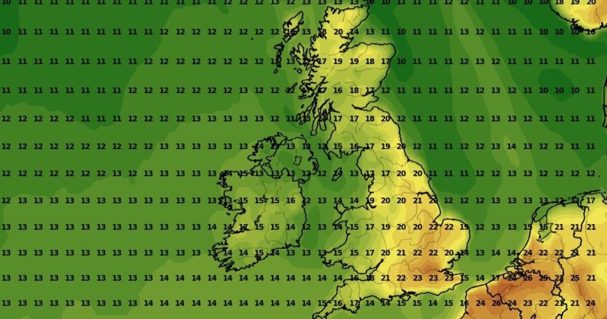
New weather maps shows that temperatures across the UK are set to rise significantly next week, with some areas basking in 21C. Maps produced by weather experts WXCharts.com shows large parts of the country will enjoy temperatures in excess of 20C on May 14, with Scotland likely to be the warmest.
With the majority of the UK experiencing temperatures in excess of 20C, the country will be warmer than much of Europe, with the south of France seeing highs of 16C and much of Spain struggling to push the mercury into the twenties. A Met Office long-range forecast for the time period warned that although temperatures could be higher than normal, they could still be accompanied by showers and cold evenings. The forecast for May 11 – May 20 said: “Dry across the majority of the UK with clear or sunny spells for many areas as high pressure dominates the weather pattern across the UK.
“However, at the start of this period, thicker cloud is likely in the far north for a time with some patchy rain and drizzle in north and northwest Scotland.
“Similarly, over the first few days of this period, cloud will probably thicken in parts the southwest with a few showers in places, with a small chance some of these could be heavy or thundery.
“Winds will mostly be light with daytime temperatures likely to be slightly above normal for the time of year, although there is a chance of some cold nights.”
The warm spell follows April, which was the sunniest month on record, with an average of 228.9 hours of sunshine, the sunniest April since records began in 1910.
The mean temperature for April was 9.6°C, which is 1.7°C above the UK average. This makes it the third warmest April for mean temperature since the series began in 1884. The warmest was 10.7°C recorded in 2011.
Met Office Meteorologist Aidan McGivern said: “High pressure sat over the UK for the first two weeks of April as well as the last week, with low pressure bringing some unsettled weather in the middle. This has meant temperatures have been above average, and rainfall, for most, has been below.
“The last week of April has closed out with temperatures well above the seasonal average, with station records for temperatures and sunshine broken.
“The reason for the high temperatures over the last week has not been because we’ve been importing warm air from the south, but because cloud-free skies have brought strong solar insolation, warming the air up day-by-day.
“The sun is as strong at this time of year as it is in August. Under high pressure, the air tends to sink, get compressed, and warm up. So, it’s fair to say that this latest period of very warm weather has been ‘home-grown’ and not brought in from anywhere else.”